Home > Activities > Let’s Explore by Bicycle

Let’s Explore by Bicycle

We invite you to rent bicycles at the manor to explore the wider surroundings, enjoying a bit of exercise while taking in the beautiful views that unfold along your journey. We will suggest cycling routes through Mielagėnai, the village of Mėčionys, and many other remarkable natural and cultural landmarks easily reached by bike from Paliesius! Most of the roads are paved, with only short stretches of gravel.

Upon request and by prior arrangement, we can also offer special encounters with local residents during your cycling trip.


Tourist routes from Paliesius Manor


ROUTE 1:

Paliesius Manor – Mėčionys – Kukutėliai – Tverečius – Senoji Katinautiškė – Guntauninkai – Gilūtos – Paliesius Manor

Route length: ~ 35 km (~ 2.5 hours)

Map


READ MORE

Paliesius Manor

The estate remembers times as far back as the 17th century, when Count Tyzenhauz acquired the manor here. Unique in her landscape and mysterious variety, nature herself whispered the name of the locale: that which lies by the small forest, or “paliesiuje”. And so the area of Paliesius was born, and Paliesius Manor became its center.

The twists of history have changed the life of the estate, yet today, Paliesius Manor—having preserved the spirit of centuries and awakened to a new life—rises once again in all its majesty. With its history reborn, it becomes a center of attraction anew. Symbols will accompany you everywhere you wander here: whether in the stones of the buildings guarding centuries of secrets, in a bird’s song, in the whispering dewy grass of morning, in the scent of cinnamon buns just pulled from the oven, or in the resonant notes of music…


Mėčionys (3 km from Paliesius Manor)

An ethnographic street village in the Ignalina district municipality, located 5 km northeast of Mielagėnai. This double-sided linear strip village preserves valuable ethnological homesteads and individual buildings from the late 19th and early 20th centuries, including 8 heritage homesteads and 7 individual heritage structures.


Kukutėliai (3.5 km from Mėčionys)

A linear strip village situated 6 km southwest of Tverečius, on the western shore of Lake Erzvėtas. The main street divides most of the homesteads into two parts. On one side stand traditional cottages built with their gable ends facing the street, often connected to barns and granaries; on the other side lie bathhouses and planted orchards. The village retains valuable buildings from the late 19th and early 20th centuries, including double-ended traditional cottages with barns, a granary, and various structures of small-scale architecture.


Tverečius (7.5 km from Kukutėliai)

A town in the Ignalina district municipality, located 33 km east of Ignalina, near the Lithuanian state border with Belarus (the border follows the Dysna River).

In the town of Tverečius, by the church, stands a mighty oak—a state-protected natural botanical landscape object. The Tverečius oak reaches a height of 28 meters, with a trunk circumference of 5.5 meters. Before the Second World War, the top of the oak was cut off. The tree grows on the site of an ancient Lithuanian pagan sanctuary. According to legend, during the Christianization of Lithuania in 1387, a local pagan priest extinguished the sacred fire and drove an oak staff into the earth with his fist, from which the Tverečius oak then grew. It has been under protection since 1960.

Further to the southwest lies the Vytėnai bog (a telmological reserve). Northwest of the town is the Tverečius barrow field, dating to the 9th–12th centuries.


Senoji Katinautiškė (7.2 km from Tverečius)

A clustered village in the east of the Ignalina district municipality, located 5 km south of Tverečius, on the banks of the Svyla River. South of the village lies Lake Katinautiškė, and to the north, Lake Petrošiūnai.

The clustered village is one of the oldest settlement types in Lithuania. It is believed that such villages flourished during the 13th and 14th centuries.

A clustered village is made up of homesteads scattered freely, without any strict geometric plan. Sometimes, neighboring lands even interweave with one another. Not many clustered villages remain in Lithuania today.

Senoji Katinautiškė is a classic example of a clustered village characteristic of the Aukštaitija region.


Guntauninkai (3.1 km from Senoji Katinautiškė)

A village in the Ignalina district municipality, located 4 km northeast of Gilūtos, by the Svyla River and its tributary, the Audenėlė. Further east loom the Adutiškis forests. Road 4402 (Adutiškis–Jakeliai–Tverečius–Vidžiai) passes through the settlement. The village has preserved the traditional layout and architecture of eastern Aukštaitija.


Gilūtos (4.6 km from Guntauninkai)

A village 6 km east of Mielagėnai. It is the center of the local sub-eldership and features a library. In the east of the village flows the Svyla, a tributary of the Birvėta, while to the west flows the Gilūta, which empties into the Svyla at the northern edge of the village. On the western outskirts of the settlement stands a monument to Lithuanian freedom—a traditional carved chapel post dedicated “To those who died and suffered for the freedom of Lithuania.”

The village was first mentioned in 1744. In 1830, there were 21 homesteads in the village.


Paliesius Manor (4.5 km from Gilūtos)

ROUTE 2:

Paliesius Manor – Mielagėnai – Ceikiniai – Kačėniškė Hillfort – Ceikiniai – Krikonys – Juodagalviai – Mielagėnai – Paliesius Manor

Route length: ~ 40 km

Map


READ MORE

Paliesius Manor

The estate remembers as far back as the seventeenth century, when Count Tyzenhauz acquired the manor here. With its unique landscape and mysterious diversity, nature itself whispered the name of this place: that which lies by the small forest, or paliesiuje. Thus, the Paliesius area was born, with Paliesius Manor standing as its heart.

The turning tides of history shaped the life of the estate, yet today, having preserved the spirit of the centuries, Paliesius Manor has awakened for a new era. It rises once more in all its reborn majesty, becoming a true center of attraction. Here, symbols will accompany you at every step—whether in the ancient building stones guarding centuries of secrets, the song of a bird, the whisper of dewy grass in the morning, the scent of cinnamon rolls pulled fresh from the oven, or the resonant strains of music…


Mielagėnai (2.8 km from the manor)

A town in the Ignalina District Municipality, serving as the center of the local eldership and sub-eldership. The town is home to the Church of St. John the Baptist, built in 1790. Together with its bell tower and fence, it stands as an architectural monument.

The Kančiogina river flows through Mielagėnai, and 4 km southeast of the town lies the Milašius Landscape Reserve.

Mielagėnai has been mentioned in historical records since 1515. The Mielagėnai Manor, first mentioned in 1656, was owned by the nobleman Fabijonas Roličius-Kochanskis. Documents from 1736 reveal that the Paliesius, Mielagėnai, and Krikonys manors were owned by Justina and Kazimieras Petras Kublickas, cup-bearers of Livonia.

In 1768, Stanisław August, ruler of the Polish–Lithuanian Commonwealth, granted Mielagėnai the privilege of hosting three annual fairs and a weekly market.


Ceikiniai (12.1 km from Mielagėnai)

A village in the Ignalina District Municipality, serving as the center of the local eldership and sub-eldership. It is home to the Ceikiniai Church of the Holy Name of Mary, a post office, and the Ceikiniai branch of the Ignalina Česlovas Kudaba Basic School.

Ceikiniai is the birthplace of the renowned singer Kipras Petrauskas (1885–1968). The house where he lived is marked with a memorial plaque. Beside the church, you can take a seat on a little bench that will sing to you.


Kačėniškės Hillfort (5 km from Ceikiniai)

One of the most impressive hillforts in Lithuania, Kačėniškės Hillfort rests on the western shore of Lake Mergežeris. Surrounded by the lake and marshy lowlands, its steep slopes rise to a height of about 20 The hillfort’s defensive structures include a 1.5 m high embankment situated on the slope, 2.5 m below the main summit area, behind which the faint traces of an ancient moat can still be seen.

A cultural layer of an ancient settlement was discovered along the shores of Lake Mergežeris. On the slopes, fragments of hand-built pottery with a brushed surface have been found.

At the southeastern foot of the hill, right on the shore of Lake Mergežeris, the cultural layer of this ancient settlement covers an area of 0.5 ha. It is believed that the site was inhabited from the 1st millennium BC to the beginning of the 1st millennium AD.


Ceikiniai (5 km from Kačėniškės Hillfort)


Krikonys II (9.5 km from Ceikiniai)

A village in the Ignalina District Municipality, located 5 km from Mielagėnai, by the Kančiogina river.


Mielagėnai (3 km from Krikonys II)


Paliesius Manor (2.8 km from Mielagėnai)

ROUTE 3:

Paliesius Manor – Paringys – Mikalavas – Naujasis Daugėliškis – Vidiškės – Ignalina – Ceikinėliai – Ceikiniai – Mielagėnai – Paliesius Manor

Route length: ~ 60 km

Map


READ MORE

Paliesius Manor

The estate remembers as far back as the 17th century, when Count Tyzenhauz first acquired the manor here. With its unique landscape and mysterious diversity, nature itself whispered the name of the locale: that which lies by the small forest, paliesiuje. Thus, the Paliesius settlement was born, with Paliesius Manor at its very heart.

The winding paths of history have shaped the life of the estate, yet today, Paliesius Manor—having preserved the spirit of centuries and awakened to a new life—rises once again in all its grandeur. With its history reborn, it has once more become a vibrant center of attraction. Symbols will follow you everywhere here, whether in the building stones guarding centuries-old secrets, the song of a bird, the morning whispers of dewy grass, the aroma of cinnamon pastries fresh from the oven, or the resonant strains of music…


Paringys (13.1 km from the manor)

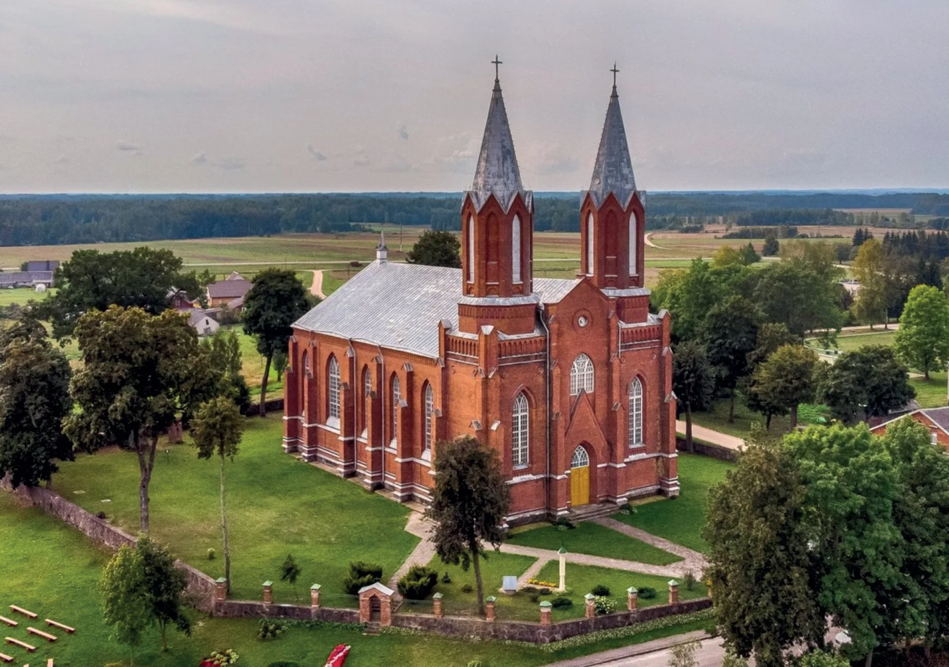
A village in the Ignalina district municipality, home to the Paringys Church of the Sacred Heart of Jesus (built in 1819).

The Paringys estate included only the village of Paringys itself. In 1795, five serf families (43 people) lived here. At the end of the 18th century, the Paringys estate was inherited by Count Malevskis, an official of the Ukmergė county. By the early 19th century, the estate was managed by two owners: Eleonora Venglinska Kasinska and Laurynas Babinskis.

The population of Paringys village was 53 in 1820; 86 in 1913; and 26 in 1939.


Mikalavas (3.3 km from Paringys)

A village in the Ignalina district municipality, 3 km southeast of Naujasis Daugėliškis, along road 112 (Ignalina–Didžiasalis). An Old Believers’ church stands here. The Virėkšta stream flows through the village, while Lake Mikalavas lies to the south. Roads branch off toward Senasis Daugėliškis and Bernotai.

The Mikalavas cemetery is located in the neighboring village of Pajurgiškė.


Naujasis Daugėliškis (3.6 km from Mikalavas)

A village in the Ignalina district municipality, 10 km northeast of Ignalina, near road 112 (Ignalina–Didžiasalis). It serves as the center of the eldership and sub-eldership. Here stands the wooden Naujasis Daugėliškis Church of Sts. Joachim and Anne (built in 1889).

Naujasis Daugėliškis was established next to the village of Senasis Daugėliškis, from which it takes its name. The place name Daugėliškis is derived from the personal name Daugėla(s).


Vidiškės (6.3 km from Naujasis Daugėliškis)

A village in the Ignalina district municipality, 5 km northeast of Ignalina, along the road to Tverečius. The center of the eldership, the settlement includes two sub-elderships. It is home to the Vidiškės Church of the Visitation of the Blessed Virgin Mary (since 1906) and the surviving 18th-century Vidiškės manor complex, which consists of six buildings. Between the small Lake Varnys and the manor house standing on a high slope, a sizable, shady park unfolds.


Ignalina (5.5 km from Vidiškės)

A city in northeastern Lithuania, within the Utena county. It is the center of the Ignalina district municipality and a designated resort area.

In the city stands the Ignalina Church of the Nativity of the Blessed Virgin Mary (built in 1999).

The city’s name is an estate-derived toponym, originating from the male name Ignas. However, it is not known exactly whether it stems from the former folwark manager Ignas Kaminskis, or from the nobleman who later purchased it, Ignas Tyzenhauz—though the latter is considered more likely.

Ignalina is situated in a region rich with lakes. Within the city itself lie Šiekštys and Gavaitis, while just outside the city you will find Gavys, Paplovinis, Palaukinis, Ilgys, Baltys, Varnys, Juodinis, Agarinis, Gulbinis, Mekšrinis, Budaraistis, Žiežulinis, Krakinis, Viksvojis, Paviksvojis, and Daržinėlės. The Narsupė stream also flows here.

Towering above the city is Vilkakalnis, a large, forest-covered hill (its ancient name being Trukamiškis), which hosts a TV retransmission tower and a fire lookout. Meanwhile, on the shores of Šiekštys stands an observation tower belonging to the Lithuanian Winter Sports Center.

Ignalina is home to an active Tourism Information Center, where you can find a wealth of information about local attractions. www.ignalina.info


Ceikinėliai (9 km from Ignalina)

A village in the Ignalina district municipality, 3 km from Kazokinė.


Ceikiniai (4.3 km from Ceikinėliai)

A village in the Ignalina district municipality, and the center of both the eldership and sub-eldership. It is home to the Ceikiniai Church of the Holy Name of Mary, a post office, and the Ceikiniai branch of the Ignalina Česlovas Kudaba Basic School.

Ceikiniai is the birthplace of the renowned singer Kipras Petrauskas (1885–1968). The house where he lived is marked with a memorial plaque. By the church, you can take a seat on a special bench that will sing to you.


Mielagėnai (12.1 km from Ceikiniai)

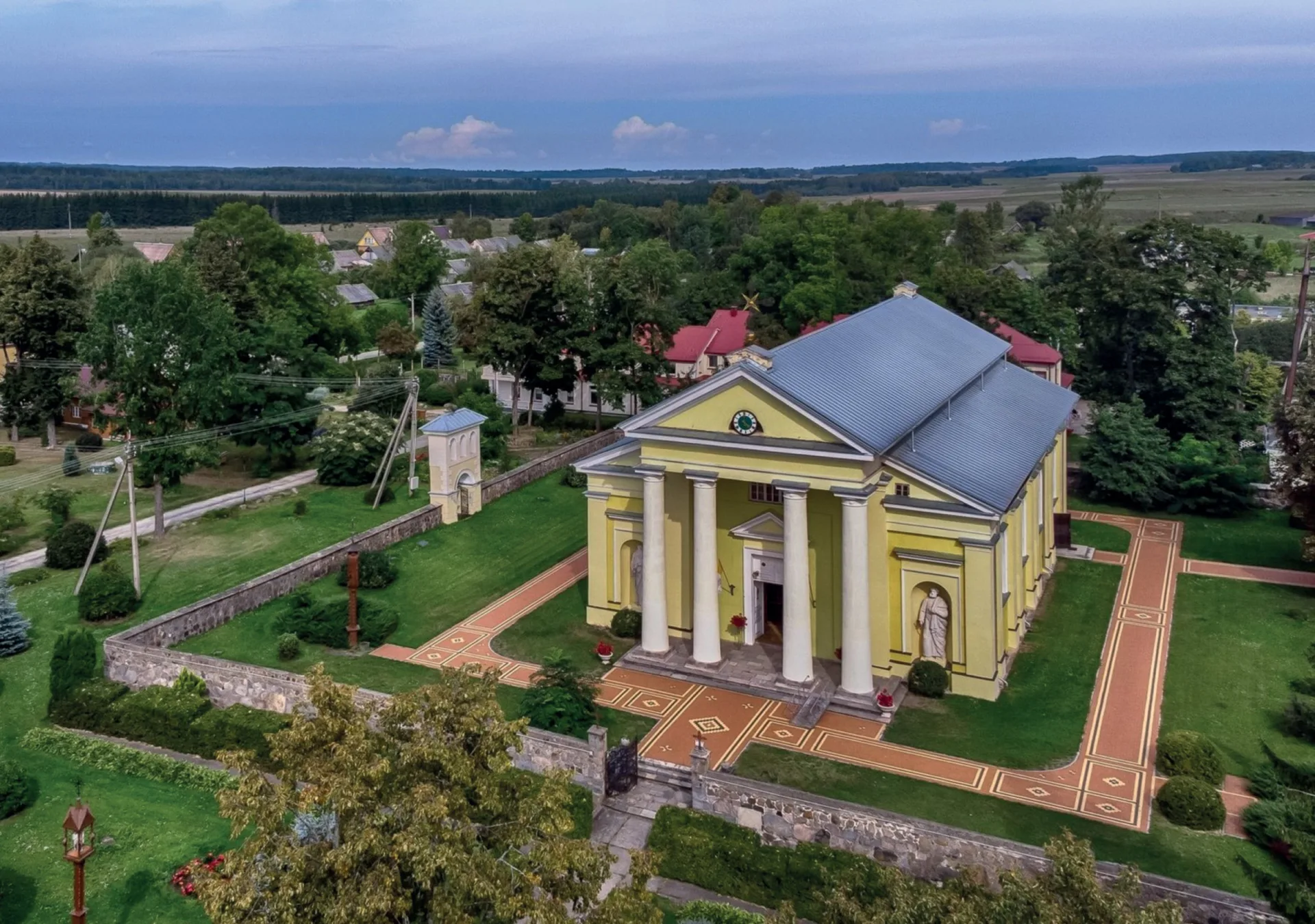
A town in the Ignalina district municipality, and the center of the eldership and sub-eldership. The town features the Church of St. John the Baptist, built in 1790. Together with its bell tower and fence, it stands as an architectural monument.

The Kančiogina river flows through Mielagėnai, and 4 km southeast of the town lies the Milašius Landscape Reserve.

Mielagėnai has been mentioned in historical records since 1515. The owner of the Mielagėnai estate, first mentioned in 1656, was the nobleman Fabijonas Roličius-Kochanskis. Documents from 1736 reveal that the owners of the Paliesius, Mielagėnai, and Krikonys estates were Livonian cup-bearers Justina and Kazimieras Petras Kublickas.

In 1768, the ruler of the Polish–Lithuanian Commonwealth, Stanisław August, granted Mielagėnai the privilege of hosting three annual fairs and a weekly market.


Paliesius Manor (2.8 km from Mielagėnai)

BICYCLE RENTAL

BICYCLE RENTAL:

Adult10 € / day
Child5 € / day